
Application Description
GPS Waypoints: Your All-in-One Mapping and Surveying Solution
The GPS Waypoints app is a versatile tool perfect for both personal and professional use. Its user-friendly design and powerful features make it ideal for a wide range of applications, from agriculture and forestry to infrastructure management and beyond.
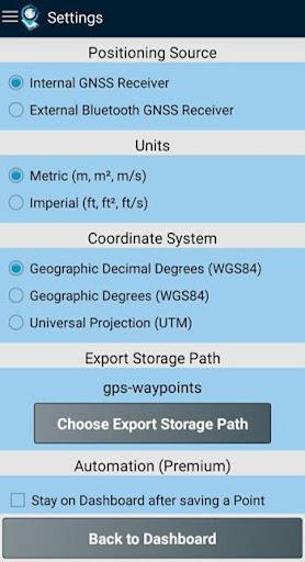
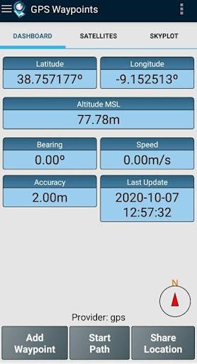
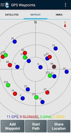
Easily collect data, create routes, and categorize points of interest using tags and photos. GPS Waypoints also excels at measuring distances, calculating areas, and exporting data in various formats (KML, GPX, CSV), making it a valuable asset for any project. Whether you rely on the built-in GPS or connect an external GNSS receiver for enhanced precision, this app delivers accurate and reliable results. Premium subscriptions unlock even more advanced professional capabilities.
Key Features:
- A multi-purpose mapping and surveying app for professional and personal use.
- Ideal for various professional land-based surveying tasks, including agriculture, forestry, infrastructure maintenance, urban planning, real estate, and emergency response mapping.
- Excellent for personal outdoor activities like hiking, running, walking, travel, and geocaching.
- Collect and manage Points of Interest (POIs) and Paths (sequences of POIs).
- Classify POIs with custom tags and photos; create Paths as temporal sequences or using existing POIs to define routes.
- Export Points and Paths to KML, GPX, or CSV files for external geospatial processing.
In Conclusion:
GPS Waypoints stands out for its intuitive interface, robust feature set, and commitment to compatibility and user feedback. It's an indispensable tool for anyone requiring precise and efficient data collection and analysis in the field.
GPS Waypoints Screenshots

Reviews
Post Comments
Trending Games
Trending apps


![NULL [Remastered]](https://imgs.39man.com/uploads/71/1719651062667fcaf6c483b.png)


Topics
More
Best Tools for Home Improvement Projects
Fun Educational Games to Learn and Play
Immersive Strategy Games: Dive into Tactical Combat
Hyper-Casual Games: Fun and Addictive Mobile Games
Essential Tools for Everyday Life
Top Lifestyle Apps to Enhance Your Life
Top-Rated Adventure Games to Play Now
Best Strategy Games for Android