
Application Description
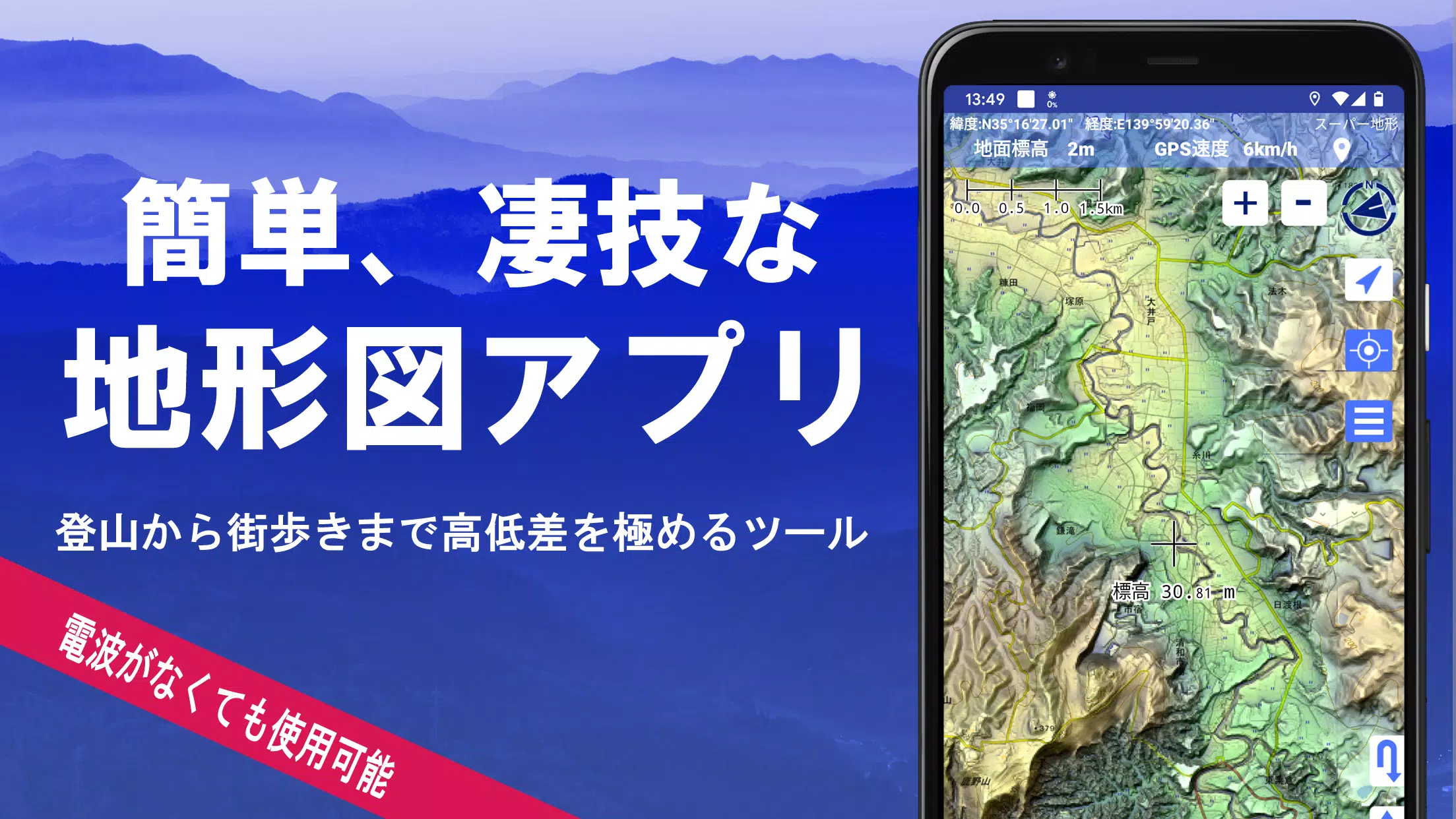
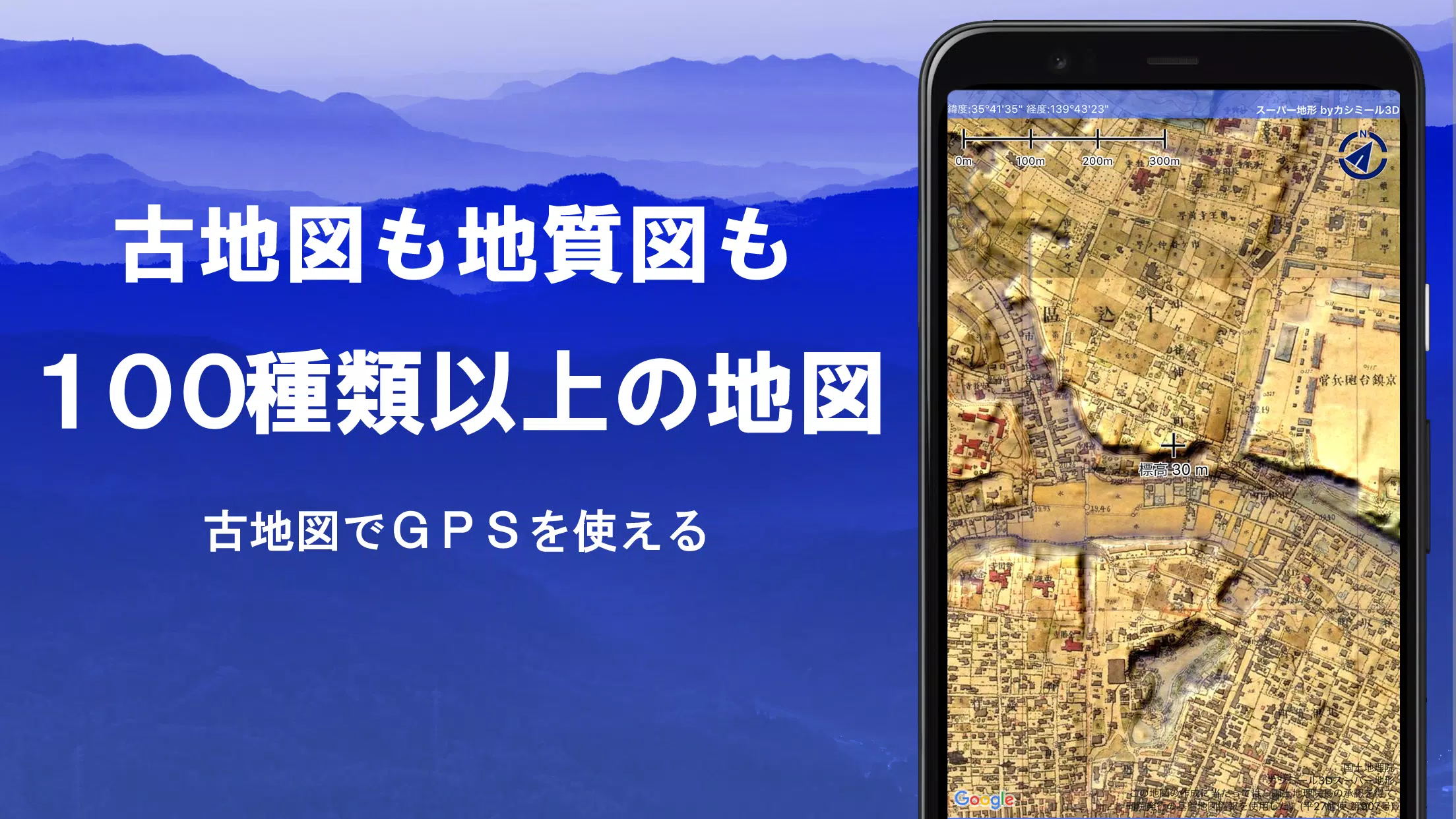
Explore a world of possibilities with over 100 types of maps at your fingertips, from detailed Geographical Survey Institute maps to your own customized maps. Whether you're scaling mountains or strolling through town, these maps leverage the height differences to enhance your experience. In 2018, our app was honored with the Japan Cartographic Society Award for Best Work, underscoring our commitment to excellence.
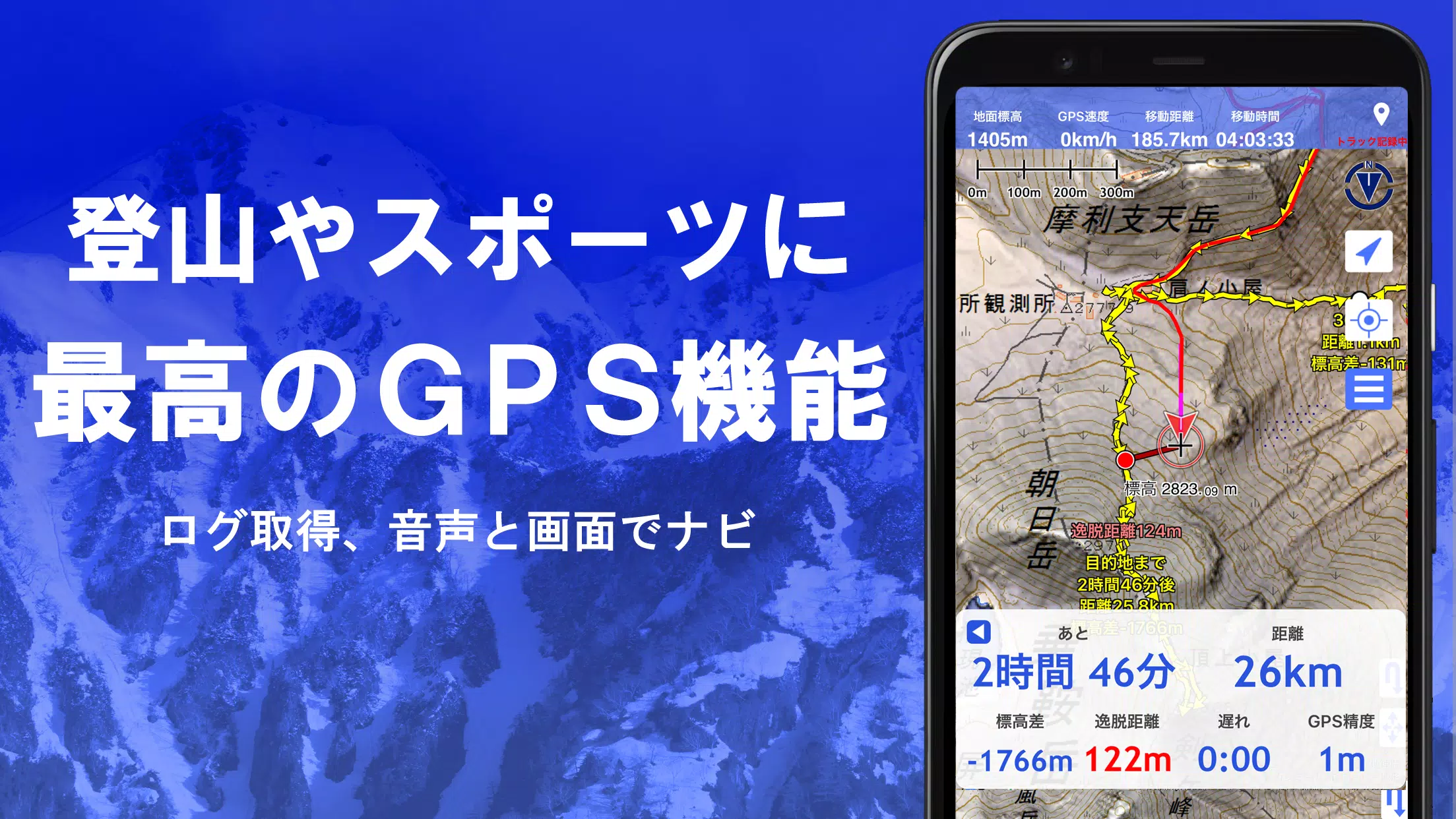
Our unique "super terrain data" technology brings the terrain to life, and you can access a wide range of maps, including those from the Geospatial Information Authority of Japan, topographic maps, geological maps, old and prewar maps, and more. With the GPS function, you can record your tracks (trajectories) and utilize GPX log input/output and editing features. Our app is equipped with tools to support your urban walks, mountain climbing, and outdoor adventures, including GPS navigation with audio, and data recording and editing capabilities.
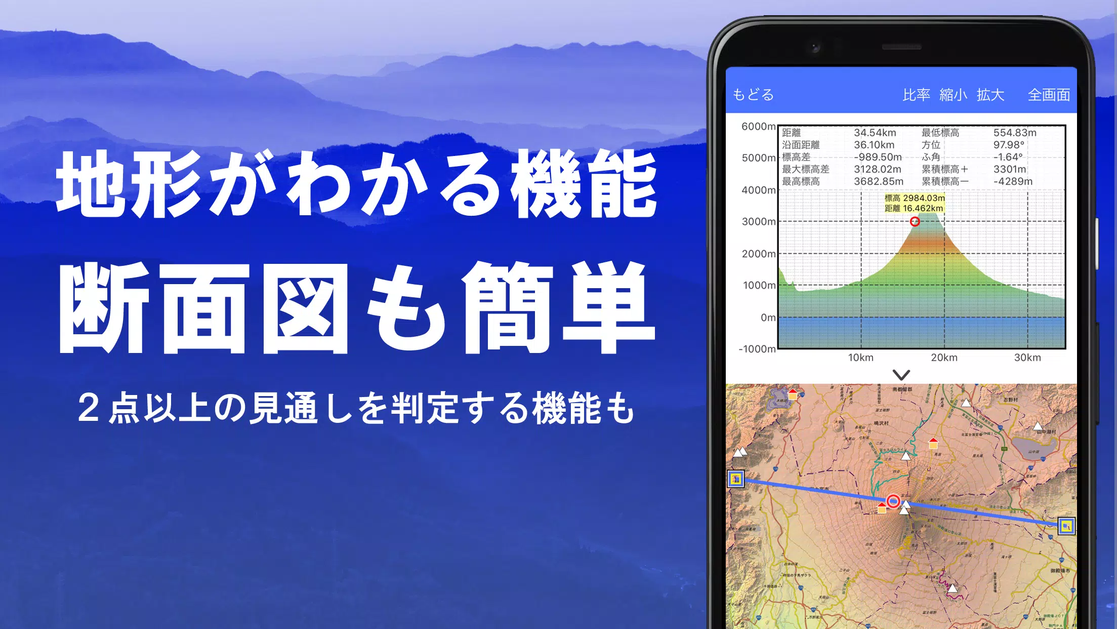
Enhance your exploration with our visibility determination function, perfect for creating cross-sectional diagrams, observation, and radio communication. You can even display buildings. Enjoy a 360° panoramic view that includes a mountain identification feature to name the peaks you see. You can also track the sun, moon, and your GPS points.
Our app's GPS functionality ensures a comfortable offline experience, even in areas without a radio signal, thanks to bulk map downloads and a map cache function. You can associate photos with specific points, display contour lines from elevation data, show MGRS (UTM) grids, and handle GIS data from GeoJSON files. Additionally, you can draw shapes, use the app overseas, print maps, output to PDF, and enjoy a dark theme.
A Wealth of Maps at Your Disposal
Our app offers over 100 types of maps, including our proprietary super topographic data and maps from the Geospatial Information Authority of Japan, hazard maps, and more. Aerial photographs are available by age group, though coverage may vary. Notably, the "latest" and "around 1974" sets have extensive coverage. You can use maps featuring super terrain data for free for the first 5 days after installing the app.
Creating Cross Sections and Outlooks
Effortlessly draw cross sections through any point on the map. Our app includes a visibility judgment function, akin to Kashmir 3D, which accounts for the Earth's curvature and atmospheric conditions. This is invaluable for route planning during climbs, assessing wireless visibility, and understanding terrain. Where PLATEAU building data is available, you can generate cross-sectional views including buildings.
Elevation Palette Function
Customize your map's appearance with our elevation palette function, allowing you to change the background color in 1cm increments to your preferred gradation.
Panoramic View
Our panoramic observation map lets you identify mountains from any location on the map. Linked with your smartphone's compass, this 360-degree view is a powerful tool for mountain identification. You can also display the sun and moon, including moon phases, which is great for spotting phenomena like Diamond Fuji and Pearl Fuji. Additionally, you can view GPS points and draw panoramic views of mountains abroad.
GPS Function
Utilize your smartphone's GPS to obtain location data and record tracks. Our high-precision positioning is designed for serious mountain climbing and outdoor use. You can graphically display recorded tracks with details such as elevation change, speed, time, and elapsed time. The point alarm feature alerts you with voice and sound as you near a point. Photos can be linked to specific points, and you can send the map center position to NaviCon.
GPS Track Summary Playback
This function lets you replay your tracks in full, automatically displaying photos taken at corresponding times. Icons indicate photo locations, which you can view by tapping.
GPS Navigation Function
Navigate preset tracks with our Track Navi feature, which alerts you with voice or sound if you deviate from the path. This prevents getting lost during climbs. Additionally, you can use route navigation for urban walks and point navigation to reach a specific location.
GPS Data Editing Function
Manage GPS-related point, route, and track data in folders, displayed in an easy-to-read tree format. You can create tracks directly on the map and import/export them in GPX format from mountain climbing sites.
Map Usage Outside the Service Area (Offline)
Use maps even in areas without signal, such as during mountain climbing. The bulk download function ensures you can download all scale maps of a specified area. A cache function is also available.
Map History Function
The app remembers your previous locations, allowing you to return to them easily.
Custom Map Compatibility
Import and use custom maps created with Kashmir 3D's map cutter. Display your own maps and scanned images as maps. When using the map cutter, divide each image into approximately 256 x 256 pixels and send the resulting kmz file to Super Terrain via email or Cloud Drive.
GeoJSON Compatibility
Display and edit points, linestrings, and polygons from GeoJSON format files. You can also draw new shapes.
Print/PDF Output
Print any area of the map at a specified scale or create a PDF.
Cooperation with Other Apps
Input and output GPS data in GPX, KML, and GDB formats, facilitating data exchange with other apps, PC software like Kashmir 3D, and trajectory data from mountain climbing sites.
Backup Function
Backup all app data (excluding map caches) and remove it from your smartphone. You can restore this data if you delete the app or if your smartphone malfunctions. An automatic backup feature using Google Drive ensures your data is always up-to-date. For detailed instructions, refer to the manual.
About Billing Function
Some functions, such as maps using super terrain data, GPS track functions, and cross-sectional views, require in-app purchases. Post-purchase, the number of search results for place name searches increases.
- Fees: Annual payment of 780 yen/year.
- Free Trial: Use the app for free for 5 days after installation. After 5 days, some features and maps will be unavailable unless you purchase them. You will not be charged without a purchase operation.
- Confirmation and Cancellation: Check or cancel automatic updates via Google Play under "Regular Purchase" and select "Super Terrain."
- Price Revision: Prices may change with future feature enhancements. Early purchase is beneficial.
Terms of Use
The copyright holder and developer are not responsible for the outcomes of using this application. When starting GPS for the first time, you'll be prompted to allow location services. Continuous GPS use can drain your battery; if your device is used for emergency communication, carry a spare battery. For an easy-to-understand explanation of the navigation function, refer to the PDF at https://www.kashmir3d.com/online/superdemapp/superdem_navi.pdf. Note that some smartphones may interrupt or fail to record tracks due to power-saving features, a common issue across many apps.
スーパー地形 - GPS対応地形図アプリ Screenshots
Reviews
Post Comments
Trending Games
Trending apps

![NULL [Remastered]](https://imgs.39man.com/uploads/71/1719651062667fcaf6c483b.png)


Topics
More
Latest Articles
More


"Pokémon Go Tests Go Pass in Select Regions"
Apr 28,2025
Pikmin Bloom's Official Walk Party for Earth Day
Apr 28,2025